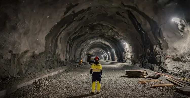
- Norway is constructing the Rogfast tunnel, set to become the world’s longest and deepest undersea road tunnel, spanning 27 kilometres (17 miles) and reaching a maximum depth of 392 metres (1,286 feet) below sea level.
- Officially titled Rogaland fastforbindelse (Rogaland Fixed Link), the project will create a continuous, ferry-free highway link along the nation’s western coastline.
- The mega-infrastructure project carries an estimated total cost of approximately 25 billion Norwegian kroner (about $2.4 billion / €2.2 billion).
- Initially launched in January 2018, construction was suspended in late 2019 following projected cost overruns, leading to contract cancellations and restructuring before operations resumed in late 2021.
- The project target completion date is slated for 2033, serving as a critical segment of the broader E39 coastal highway modernization scheme.
- Subsea construction is led by multinational contractor Skanska, which is building the northern 9-kilometre section containing the tunnel’s deepest points.
- The dual-tube tunnel architecture features a unique subterranean double roundabout positioned 260 metres below sea level, connecting out to the island municipality of Kvitsøy.
- Precision engineering measures employ advanced laser scanning to produce 2-million-data-point-per-second “digital twins,” ensuring construction teams meeting from opposite ends align within a strict 5-centimetre (1.97-inch) margin of error.
- Extensive high-pressure saltwater leaks at depths exceeding 300 metres below sea level have required specialized rock-grouting techniques to maintain structural integrity and worker safety.
- Upon completion, the tunnel will eliminate existing ferry legs, cutting transit times between Norway’s second and fourth largest cities—Bergen and Stavanger—by roughly 40 minutes.
Norway (Norway Post Magazine) November 10, 2026 – Work is progressing across western Norway on the Rogfast tunnel, a landmark engineering effort that will establish the world’s longest and deepest undersea road tunnel upon its planned completion in 2033. Spanning 27 kilometres (17 miles) and descending to 392 metres (1,286 feet) below sea level, the 25-billion Norwegian kroner ($2.4 billion) project will fundamentally transform transportation along the country’s fractured western coastline. By substituting existing maritime ferry routes with twin-tube subsea road infrastructure, the megaproject directly connects the Stavanger and Haugesund regions while shaving 40 minutes off transit times between Bergen and Stavanger. The development forms an integral anchor of Norway’s overarching 1,100-kilometre E39 coastal highway overhaul, which seeks to eliminate all seven highway ferry crossings by 2050.
- How Does the Rogfast Tunnel Compare to World Depth and Length Records?
- What Is the E39 Coastal Highway Upgrade Plan?
- How Are Engineers Overcoming Extreme Subsea Construction Hazards?
- Background of the Particular Development After the News
- How This Development Can Affect Regional Economies, Transport Logistics, and Civil Engineering
As reported by civil engineering correspondents and international infrastructure outlets covering Scandinavian transport developments, construction on the Rogfast link—short for Rogaland fastforbindelse—represents one of the most complex subsea civil engineering endeavors ever undertaken in Northern Europe. Designed to streamline traffic flows across the fjord-indented Rogaland province, the fixed-link system consists of two separate parallel tunnel tubes, each hosting two dedicated lanes of vehicular traffic.
The project originally broke ground in January 2018 but suffered a major setback in late 2019 when severe cost overrun projections forced the Norwegian Public Roads Administration (Statens vegvesen) to halt operations, terminate existing procurement contracts, and completely restructure the financial framework. Following financial re-authorization and contract re-bidding, physical excavation work officially resumed in late 2021. The current operational schedule targets full infrastructure commissioning by 2033 at an overall cost of approximately 25 billion Norwegian kroner.
Addressing the strategic scope of the northern construction sector, Anne Brit Moen, project manager at multinational construction firm Skanska—the entity contracted to build the deepest 9-kilometre (5.5-mile) northern stretch of the tunnel—stated that “The tunnel will significantly improve connectivity along the Norwegian west coast by creating a faster and more reliable link between the Stavanger and Haugesund regions.”
Elaborating further on the daily practical impact for regional commuters and logistics networks, Moen added that by replacing existing maritime ferry schedules, Rogfast will reduce driving times between Bergen and Stavanger—Norway’s second and fourth largest urban centers by population—by approximately 40 minutes, while rendering routine daily commuting vastly more predictable.
Engineers have highlighted several unprecedented architectural features built into the subterranean passage. Roughly halfway along the 27-kilometre route, designers have engineered a massive double roundabout situated 260 metres beneath the ocean surface. This underground junction connects directly to a secondary connecting tunnel that ascends to serve Kvitsøy, Norway’s smallest municipality by land area, integrating the isolated island community directly into the national highway network.
To execute excavation work of this magnitude beneath intense oceanic pressures, construction crews are drilling simultaneously from both northern and southern headings. The engineering parameters require the two underground tunneling teams to meet in the center of the seabed rock formation with a maximum allowable alignment deviation of just 5 centimetres (1.97 inches).
Explaining the high-tech surveying methods utilized to achieve this precision, Burkhard Boeckem, chief technology officer at Hexagon—the measurement technology firm overseeing project alignment—stated that “It’s a little bit away from the romantic view of the surveyor looking through an eyepiece.”
Detailing the real-time digital mapping process, Boeckem explained that rotating, mirrored laser scanners collect up to 2 million spatial data points per second following each fresh excavation blast. This data continuously constructs an exact “digital twin” of the excavated rock surface, which is immediately cross-referenced against master architectural blueprints to catch structural micro-variations.
Stressing the financial and operational necessity of maintaining the 5-centimetre tolerance margin, Boeckem noted that “If you deviate from this, you create so much more material that needs to be taken out, and then so much more to be filled in again — it’s a lot of whole trucks. So, it’s not just a risk factor, but also a very financial factor.”
Describing the harsh physical conditions encountered hundreds of metres below the Atlantic seabed, Moen confirmed that the project has posed major technical hurdles. “The main challenge so far has been to find good enough grouting methods to seal the rock,” Moen explained. “We are now 300 meters (984 feet) below sea level, and we have already had quite extensive saltwater leaks in the tunnel system. Since we are going all the way down to 392 meters (1,286 feet) below sea level, we’re focusing on finding the best methods to maintain safe and efficient working conditions for everyone.”
To safeguard motorists from toxic vehicle emissions over the 27-kilometre transit, project engineers are installing a longitudinal ventilation system powered by high-capacity jet fans, working in tandem with vertical exhaust shafts extending upward to the surface at Kvitsøy. As Moen outlined, “This combination is designed to ensure effective air circulation and safety throughout the tunnel’s considerable length.” The facility will also feature real-time incident detection architecture, utilizing a network of radar installations and closed-circuit cameras to automatically flag vehicular breakdowns, accidents, or traffic congestion.
Acknowledging the socio-economic transitions associated with fixed subsea links, Moen noted that while the eventual phase-out of ferry services will result in direct job losses within the maritime transit sector, Rogfast will unlock broader economic benefits. “The project also creates substantial employment during construction and lays the groundwork for more sustainable and integrated regional development along Norway’s fractured western coastline,” Moen stated, emphasizing that lower freight and logistics overheads will allow regional enterprises, particularly the seafood export industry, to operate across expanded commercial territories.
How Does the Rogfast Tunnel Compare to World Depth and Length Records?
When completed, Rogfast will establish a new global benchmark for subsea vehicular infrastructure, although specific railway tunnels retain overall length records:
| Tunnel Project | Country | Total Length | Undersea Length | Maximum Depth Below Sea Level | Primary Transport Type |
| E39 Rogfast | Norway | 27.0 km (17.0 mi) | 27.0 km (17.0 mi) | 392 metres (1,286 ft) | Motor Vehicle Highway |
| Seikan Tunnel | Japan | 53.85 km (33.5 mi) | 23.3 km (14.5 mi) | 240 metres (790 ft) | Heavy Rail |
| Channel Tunnel | UK / France | 50.46 km (31.35 mi) | 37.9 km (23.5 mi) | 115 metres (377 ft) | High-Speed Rail |
| Ryfylke Tunnel | Norway | 14.3 km (8.9 mi) | 14.3 km (8.9 mi) | 292 metres (958 ft) | Motor Vehicle Highway |
While Japan’s Seikan Tunnel and the Channel Tunnel possess longer total footprints, both are strictly rail-only structures operating at significantly shallower depths. Rogfast will comfortably surpass Norway’s existing Ryfylke tunnel—currently the world’s deepest road tunnel at 292 metres below sea level—by a margin of 100 vertical metres.
What Is the E39 Coastal Highway Upgrade Plan?
The Rogfast development functions as a flagship milestone within Norway’s master infrastructure plan: the complete overhaul of European route E39.
- Corridor Extent: The E39 coastal highway stretches 1,100 kilometres (684 miles) along Norway’s western littoral, running from Kristiansand in the south to Trondheim in the north.
- Current Transit Bottlenecks: Navigating the entire route currently requires approximately 21 hours of travel time, heavily constrained by seven separate vehicle ferry legs crossing wide fjords.
- Strategic Objective: The Norwegian Ministry of Transport aims to transform the E39 into a continuous, ferry-free highway corridor by constructing a complex sequence of floating bridges, subsea suspension structures, and deep-rock tunnels.
- Timeline and Impact: Full completion of the multi-decade E39 upgrading program is anticipated by 2050, cut total driving times along the western corridor roughly in half.
How Are Engineers Overcoming Extreme Subsea Construction Hazards?
Tunneling nearly 400 metres beneath the ocean surface introduces unprecedented geotechnical and environmental hazards that require novel engineering solutions:
- High-Pressure Grouting and Water Ingress: At depths approaching 400 metres, hydrostatic water pressures reach nearly 40 atmospheres. Construction crews utilize specialized chemical and micro-cement grouting injections drilled deep into the rock ahead of the main tunnel face to seal fractures and halt high-pressure saltwater infiltration.
- Laser-Guided Digital Twins: Using Hexagon 3D laser-scanning technology, engineers capture 2 million measurements per second to build live digital models. This enables instant verification of structural boundaries, preventing costly over-excavation or alignment drift beyond the strict 5-centimetre tolerance limit.
- Advanced Air Quality Architecture: Longitudinal jet fans combined with a vertical ventilation shaft rising to the surface at Kvitsøy continuously flush out carbon emissions and particulate matter, maintaining safe breathing conditions for motorists across the 27-kilometre drive.
- Subterranean Traffic Safety Systems: Integrated radar tracking, automated CCTV anomaly detection, and wide-span emergency cross-passages every 250 metres provide instant alerts and evacuation routes in the event of vehicle fires, crashes, or severe congestion.
Background of the Particular Development After the News
The conceptual planning for the Rogfast fixed link dates back several decades, driven by western Norway’s unique geographic layout. The region’s economy generates a vast proportion of Norway’s national wealth through offshore oil and gas, maritime shipping, industrial aquaculture, and seafood exports. However, the terrain—characterized by steep mountains, deep fjords, and island archipelagos—has historically constrained overland transport, relying heavily on state-subsidized ferry networks that are vulnerable to severe weather disruptions and strict operating schedules.
Following extensive feasibility studies, the Norwegian Parliament (Stortinget) formally approved the construction of Rogfast in May 2017 as part of the National Transport Plan. Early construction commenced in January 2018 under the supervision of the Norwegian Public Roads Administration. However, complex subsea geological conditions, combined with escalating material inflation and revised safety requirements, led to projected cost overruns exceeding several billion kroner.
In December 2019, the project was put on hold, and existing major contracts were formally canceled to safeguard public funds. Over the subsequent 18 months, the government restructured the project’s financial risk model and division of work contracts. Following parliamentary re-approval of an updated budget of approximately 25 billion kroner, main contract awards were granted to major civil engineering groups—including Sweden’s Skanska and Norwegian contractors Implenia and Risa—allowing tunnel excavation to resume in late 2021.
How This Development Can Affect Regional Economies, Transport Logistics, and Civil Engineering
The successful completion and opening of the Rogfast tunnel in 2033 will generate wide-ranging structural impacts across Scandinavian business sectors, local communities, and international infrastructure development:
1. Western Norway Seafood and Commercial Logistics Sectors
For Norway’s multi-billion-dollar salmon aquaculture and seafood export industries, Rogfast will yield immediate supply-chain efficiencies. Replacing weather-dependent ferry crossings with a continuous, 24-hour subsea road link will eliminate transit delays, allowing fresh seafood products to reach mainland European processing hubs and air-freight terminals significantly faster. Lower freight operating costs will enhance the global price competitiveness of western Norwegian commercial exporters.
2. Local Commuters and Regional Labor Markets
The fixed link will effectively merge the distinct regional labor markets of Stavanger, Haugesund, and surrounding coastal municipalities into a single, highly integrated economic zone. Commuters will benefit from reliable, weather-independent daily transit, expanding access to specialized regional employment, higher education institutions, and centralized healthcare facilities. While local ferry operators will undergo down-scaling and staff reallocation, overall regional job creation in land transport, service sectors, and construction maintenance is projected to offset localized losses.
3. International Subsea Civil Engineering and Technology Standards
As the deepest and longest subsea road tunnel on Earth, Rogfast will establish new global engineering templates for deep-rock tunneling, high-pressure water grouting, and real-time digital twin monitoring. The techniques developed by Skanska, Hexagon, and their partner firms will likely be exported to future international megaprojects facing extreme marine environments, such as proposed deep-water fixed links in Southern Europe, East Asia, and the Middle East.